Wednesday 19 August 2020

Hiking Chutes Provincial Park - Twin Bridges Trail

How many hikes directly inspired the most famous painters in Canadian History? Aside from staying in a hotel in Victoria, which was 100 percent haunted where Emily Carr died, this hike is the closest I've come to Canadiana Group of Seven greatness. Chutes Provincial Park and the majestic views inspired the Group of Seven and their exploration of the Northern Channel. 

We went to this park to break up our drive from Manitoulin Island to Sudbury and stretch our legs. Unfortunately, because of the time of day we arrived and the surge, in temperature this moderate hike felt particularly daunting and hot, although beautiful. We normally set out at around 8 or 9 in the morning and we didn't even start this hike until lunch time.


The reason this hike is called Twin Bridges is because of the two bridges that make up some of the viewing platforms where you can enjoy the rapids.

The paths are well marked and there is the option to take a shortcut which cuts off several KMs and gives you most of the views you'll want for the chutes if you want to cut your time. You book in hourly blocks per car for this park and we bought a two hour pass.

Since we still had a few hours to kill before we could check in to our hotel in Sudbury we figured we might was well experience everything Chutes had to offer.

While we ran into many people on the shortened portion of the trail, we only ran into one group of four hikers on the remainder of our travels. The trail was very well marked.

With many tranquil little lookouts to stop and enjoy, I can see the inspiration for painting. This park would be especially stunning in the fall when the leaves change colour.


Swimming and boating is only allowed in specific areas of this park because of the strong currents and abundance of rocks.

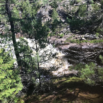
Even I must admit that this view looks like it could be a post card. This entire Provincial Park looks like it was designed by Bob Ross himself.

With some detours our hike worked out to be 6.5KM total. The last two KM were hard to take, particularly since our car was packed up so much that I was unable to locate one of our water bottles. In all fairness this was my fault though, not the hikes.

The forested trail was lovely, particularly since we had it all to ourselves. One tough aspect is that some of the rockier, biggest incline, most challenging portions of the hike are in the last 2km when you're already feeling tired.

This was a beautiful hike, but I would strongly recommend it for families with experienced hikers and kids over 6 to 8 years old. If I could have a do over I would have tackled the hike earlier in the day when it was cooler and with more drinks and snacks on hand. I would try this hike again in the fall so I could enjoy the colours a crisp October day brings. It took us two hours total to complete this hike including numerous stops. If you're in the area and up for a challenging hike, give it a go.


Monday 17 August 2020

Hiking Manitoulin Island - Bridal Veil Falls

I don't know about you, but it's been an adult-long dream to be able to swim and frolic at the foot of a waterfall. Since many of the waterfall based hikes in the Niagara escarpment area are closed because of COVID, or overcrowded, Bridal Veil Falls on Manitoulin Island seemed like the perfect option for us.

As a part of the Billings Connections Trail, this easy 2.2 km hike (1.1km out and back) takes you to and from the falls along a path peppered with inspiring art work, nature, and fairy houses. It has something for everyone.

There are viewing platforms you can see the falls from above in a parking lot above, but with COVID the stairs direct to the falls are closed. This didn't matter to us, so we headed down the main drag towards another parking lot on lower ground which led us direct to the trail with the falls.

Adorable fairy houses lined this easy going trail. 

Molly loved finding the fairy houses, but we stuck to the path because much like other hikes on Manitoulin Island there was plenty of poison Ivy.

The art work along the trail was so beautiful.


Nature was still abundant on this highly trafficked trail and the kids were pleased to spot this cute frog.


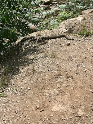
Others (me not so much) were excited to see these two sizable snakes sunning themselves at the side of the trail. 


We made it to the base of the falls quite quicky.

The kids and dad made a point of walking behind the falls. Water shoes or sandals are a good way to explore the falls without injuring your feet on the rocks. We packed ours in backpacks and put them on when we arrived at the falls. This hike is good for people of all ages, just make sure you keep an eye on little ones to make sure they don't step in poison ivy or eat any of the wild berries along the trail.

Being able to walk behind the waterfall and look out to the other side.

It was a little bit chilly out, and the water was certainly cold, but I knew I had to dive in and take a swim below and behind the falls. It was totally worth it. I'd do this hike any time I visit Manitoulin Island, and we'll definitely be back. The entire journey took just over an hour but most of that time was us stopping and enjoying the waterfall. 


Thursday 13 August 2020

Hiking The Infamous Cup & Saucer Trail - Manitoulin Island

I have been an "avid" hiker for around 12 years. Pre-kids we'd often make an entire day of a hike, dedicating time towards putting 10-15kms under our feet while we explored a new area. When the kids were little enough to be strapped to our chests we'd take on shorter hikes with them. By the time they were three we started to venture out on short mini-hikes, about 2KM in length.

I love a nice remote hidden gem of a hike, but am also guilty of scouring the interwebs for suggestions on amazing hikes in my area. The Cup & Saucer is an Instagram favourite of a trail, and just the same I wanted to hike it. This 5KM moderately difficult trail has been on my list for a while, and I'm happy that my kids were old enough to take on the challenge too.


This hike was 5KM long with an opportunity to do a 500 m "adventure" hike section. Since the journey up to the lookout was a moderate leveled hike already we opted to skip this section. I'd also read on my trusty resource All Trails that it was really easy to get lost on the Adventure trail section.

Up near one of the initial climbs is a little section where people have built Inukshuks. 

The ladder of with a broken rung at the bottom. On the journey back down we saw someone take a tumble from here, so be careful on your way in and out.

This is one of the flatter more tame parts of this challenging trail. Even though we went on a summer weekday morning it was still quite busy. Any of the kids we ran into on our travels who were under five or six were being piggybacked by their parents for at least part of the distance. We ran into several other teens who were also complaining about the distance and difficulty level. I was proud that our kids were hiking without hesitation. I wouldn't recommend this hike for anyone with a child under six or seven because of the difficulty level and because the beautiful lookouts are unobstructed, which means no railings to protect little ones. 

The famous lookout is beautiful. So we sat a while and had a snack while we drank in all the cup and saucer had to offer. The view and hike reminded me a lot of one we did in Algonquin Booth Rock Trail a couple of years ago (to read that hike review click here), but with a lot less bugs!

This hike is a challenging one, but well was worth it. Again like much of Manitoulin Island there is a lot of poison ivy so wear long pants. I couldn't believe how many tourists I saw hiking this area in sandals or flip flops instead of runners or hiking gear.   For those with better camera equipment and who are a little more adventurous, you can get some great shots of the lookout, just be safe and don't take any unnecessary risks. My favourite part of the hike was the lookout, while the kids and Chris loved the Sherwood Forest esque feel of some of the flatter parts of the trail. This hike took us about an hour and 45 minutes total including photos, lookouts, waiting for other hikers to go by to allow for social distancing, and snacks. Parking was free! Try to come early in the morning or on a weekday to beat the crowds.


Wednesday 12 August 2020

Here I Go Again - Virtually Hiking The Grand Canyon Update One

Three weeks ago I began virtually "hiking" the Grand Canyon through an app called My Virtual Fitness Challenge to help motivate me, plus I get a medal at the end! Sweet. To read about my motivations for a distanced journey during COVID-19, click here.

For the most part I'm on track, but a couple of days on the road and stuck in our car on vacation have me accomplishing only 23% of my distance in 24% of my allocated time. I currently have 69 days to get myself together and catch up. I'm confident I can do it.

On our trip away we explored many amazing hikes (most of which I'm going to feature here on the blog). The app continued to motivate me to go for more post-dinner walks and to hop on our exercise bike a few times to log more kilometres when I can.  


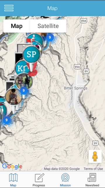
There was nothing Bitter about my trip "to" Bitter Springs.  I have to wonder what the magical elixers of this water are proposed to do to those who drink the water.

During a walk up a Collingwood area ski hill we were able to drink in this beautiful sun set.

My view atop the legendary Cup & Saucer Trail on Manitoulin Island. A really challenging way to log 5 of my kms through the Grand Canyon Challenge.

The red area is where I SHOULD be in my hike, but I'm not yet. Hopefully I'll be well ahead by the next time I check in. So far on my Mission I've completed 101.7km of the 450.6km of the Grand Canyon. I have run, hiked, walked, and biked my way to over 20 percent of the distance.  The reminders when I have been behind have been encouraging and positive (not shaming) which is the motivation I need. I'm 75 percent sure I'm going to take on another "mission" once I complete the Grand Canyon, the big question is where do I go next?

Molly has asked me to track how much distance she logs with me on this mission and as of today she's completed roughly half of the distance alongside me at 52.4kms.  I'll check in here at "basecamp" soon to report on my hiking progress.


Tuesday 11 August 2020

Hiking Manitoulin Island - Misery Bay Provincial Park

With COVID-19 still being an issue around the world, our "travel" for 2020 remains inside our province of Ontario. Thankfully, Ontario is huge, beautiful and there is plenty to explore. For our major summer vacation we rented a wonderful little AirBnB cabin on Manitoulin Island where the best of everything to do is outside anyway.

On our first full day on the island, since it was still the long weekend, we decided to travel one of the less popular hikes I'd researched. Misery Bay Provincial Park is the only operational, day use only, provincial park on the island.


Molly hiking on The Canadian Shield
Although I'd planned to tackle the 8KM Costal Alvar hike I found online, later research on Alltrails.com revealed that portions of this hike were under water because of high water levels in and around Lake Huron.  Instead we completed the 5KM Inland Alvar Trail.

Since we were there on the holiday Monday, there was no one at the visitor centre. We paid our admission via a machine ($2 each for the adults, $1 each for the kids for a reasonable price of $6 total).


So much of this hike is directly on the Canadian Shield, an ancient Alvar rock that acted like a path.

I'd only ever seen this type of plant life, sometimes called Reindeer Lichen, (frequently eaten by deer and contestants on the Survivalists History Channel show ALONE) on TV so I had to snap a picture of it.  We didn't try eating it.

One of the many cool things about this hike was how solitary it was. We truly felt like we were alone in the wilderness and the chances of us seeing some wildlife was high. We only ran into two other hikers during our entire hike, and then another two families when we returned to our car. The wildlife we saw was mostly birds and squirrels. When we arrived at the park we saw two giant hawks perched on the Park sign that we thought were statues, until they flew away.


The wild flowers on the island are so bright and vibrant I just had to snap some photos.

At various rock "clearings" we passed throughout our hike. We were able to see rock art that other hikers had created.

These are some of our favourites. People made pictures, wrote out names, and in some cases indicated the date and year, some clearly untouched from over a year ago.

This is the beach portion of the trail that overlooks Misery Bay, however the water you see here is also a part of the longer hike that we skipped because it was flooded.

This bright yellow flower is called Manitoulin Gold and is virtually everywhere, lining highways and hiking trails alike.

Another Rock clearing we found was filled with dozens of Inukshuks people had made.

Molly thought this rock art looked like Cookie Monster.  Do you see it?

Molly celebrating the end of our adventure at Misery Bay by climbing on top of a giant rock. We all highly recommend this 5KM easy hike. For all hikes on Manitoulin Island I'd suggest wearing long pants because there is a lot of Poison Ivy. We had a cool day that threatened rain the day we explored, which was perfect for long pants and a sweat shirt. Chris and I loved the raw ruggedness of this hike and the feeling like we were the only people in the world, while Molly and Jack adored seeing what rock art created by other hikers was around each corner. Definitely a must do on the island! 

It took us about two hours to complete this hike, including several stops for snacks, photos, and exploring the rock art.


To us there was nothing Miserable about Misery Bay, however according to the Website Friends of Misery Bay this is how it got the name: According to local lore, the earliest settlers—lacking hay
came to the foot of the bay to cut marsh grass for their livestock.

One warm June day in the early 1880’s, a pioneer was cutting marsh grass there when two men approached in a small boat. The boaters shouted, “What is this place called?” Hot, tired, and swatting black flies, the farmer called back, “I'm in misery!”

What the farmer did not realize was that the boaters were government surveyors, mapping the island. The surveyors wrote that name down, and it stuck. So this beautiful spot with its clear water, unique rocks, bountiful wildlife, and lovely wildflowers continues to be known as Misery Bay—a misnomer puzzling to today’s visitors.




Sunday 9 August 2020

Reflections on Turning 9

Each year, around their birthday, I ask both minions a bunch of questions to find out a bit about them.  Along with their annual birthday photo this helps both them and us look back on who they were and who they are becoming.  It amazes me how some things stay very consistent while others change drastically. They both feel very grown up all of a sudden. This morning we all watched the film Stand By Me together and the kids were enamoured with it. I'm looking forward to the number of new things we can share together this year now that they are a little bit older.


Molly Age 9


What is your favourite colour?

Black (my goth heart is singing right now)


What is your favourite toy?

Barbies


What is your favourite food?

Sushi & Shepherd's Pie & Chili cause it's delicious!


What is your favourite song?

I Never Said I Didn't Mean It (By my dads band) and Castle on a Cloud from Les Miserables.

What is your favourite movie?

Tangled and The She-ra TV Show


What is your favourite animal?

Still Sharks


What is your favourite book?

Books by Raina Telegmeier (like Smile, The Babysitters Club, Sisters & Drama) & Books by Shannon Hale, basically anything in a graphic novel about modern young girls.

What is your favourite drink?

Milk

What do you sleep with at night?

Still blankie


What do you want to be when you grow up?

A writer. I want to study animal life and write books about animals.

Jack Age 9


What is your favourite colour?

Green


What is your favourite toy?

LEGO sets to build

What is your favourite food?

Pizza & Sushi


What is your favourite song?

Take On Me By A-ha & Weezer & Old Town Road & High Hopes

What is your favourite movie?

Paranorman & Jaws and my favourite TV show is Danger Mouse


What is your favourite animal?

Shark


What is your favourite book?

The Captain Underpants and Dogman Series and The Bad Guys Series

What is your favourite drink?

Pop (Root beer & Coke, all of them)

What do you sleep with at night?

A bunch of stuffies and in my room with my sister.

What do you want to be when you grow up?

A movie maker and an author.